Log in
All resources
Create a design
Tools
6,983 Free Images of Image Editing
a class-book of modern geography (1898)
engravings of maison de victor hugo
eugène hugues
albert quantin
the pied piper of hamelin illustrated by kate greenaway
kate greenaway
maps from the earth and its inhabitants, vol. iv
maps from the earth and its inhabitants, vol. xiii
maps from the earth and its inhabitants, vol. xvi
dictionnaire populaire illustré de décembre-alonnier-tome 2
maps from the earth and its inhabitants, vol. xvii
topographic maps of new york (state)
the national portrait gallery history of the kings and queens of england
john hall (engraver)
dictionnaire populaire illustré de décembre-alonnier-tome 2
historical images of lorient
ghosts & ghoulish scenes
charles heath
a class-book of modern geography (1898)
1890s maps of egypt
a class-book of modern geography (1898)
19th-century maps of iraq
the pied piper of hamelin illustrated by kate greenaway
kate greenaway
a class-book of modern geography (1898)
old maps of the amazon river
maps from the earth and its inhabitants, vol. vii
maps from the earth and its inhabitants, vol. xiv
maps of the southern ocean
a class-book of modern geography (1898)
old maps of sydney
the pied piper of hamelin illustrated by kate greenaway
kate greenaway
a class-book of modern geography (1898)
1898 maps of the russian empire
dictionnaire populaire illustré de décembre-alonnier-tome 2
guy chabot, baron de jarnac
historical
history
a class-book of modern geography (1898)
1890s maps of colorado
a class-book of modern geography (1898)
1890s maps of australia
the pied piper of hamelin illustrated by kate greenaway
kate greenaway
a class-book of modern geography (1898)
1890s maps of hawaii
the pied piper of hamelin illustrated by kate greenaway
kate greenaway
a class-book of modern geography (1898)
1890s maps of sweden
a class-book of modern geography (1898)
1890s maps of central america
the pied piper of hamelin illustrated by kate greenaway
kate greenaway
diagrams, plots and charts from the british library mechanical curator collection
a class-book of modern geography (1898)
the pied piper of hamelin illustrated by kate greenaway
kate greenaway
a class-book of modern geography (1898)
1890s maps of montreal
the murder of edith cavell (george bellows)
ashcan school,american realism
engravings of maison de victor hugo
quatrevingt-treize
the castles and abbeys of england (1844)
floor plans of tintern abbey, wales
a class-book of modern geography (1898)
1898 maps of the united states
a class-book of modern geography (1898)
old maps of the danube
the pied piper of hamelin illustrated by kate greenaway
kate greenaway
the pied piper of hamelin illustrated by kate greenaway
kate greenaway
the pied piper of hamelin illustrated by kate greenaway
kate greenaway
the pied piper of hamelin illustrated by kate greenaway
kate greenaway
the pied piper of hamelin illustrated by kate greenaway
kate greenaway
a class-book of modern geography (1898)
1898 maps of africa
the pied piper of hamelin illustrated by kate greenaway
kate greenaway
the pied piper of hamelin illustrated by kate greenaway
kate greenaway
a class-book of modern geography (1898)
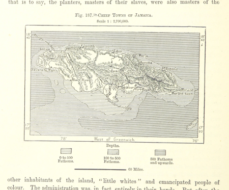
19th-century maps of jamaica
a class-book of modern geography (1898)
1890s maps of new zealand
dictionnaire populaire illustré de décembre-alonnier-tome 2
historical images of port of le havre
historical
history
british library asia, pacific and africa collections
british library india office prints collection
keizersgracht 716, amsterdam
snow in amsterdam
engravings of maison de victor hugo
albert quantin
engravings of maison de victor hugo
albert quantin
engravings of maison de victor hugo
albert quantin
engravings of maison de victor hugo
albert quantin
old images of goa
anno salutis
historical photographs of vondelpark
1923 in amsterdam
national history and views of london and its environs (1834) charles frederick partington
isaac newton's monument and grave in westminster abbey
engravings of maison de victor hugo
albert quantin
engravings of maison de victor hugo
albert quantin
engravings of maison de victor hugo
albert quantin
engravings of maison de victor hugo
albert quantin
engravings of maison de victor hugo
albert quantin
juan francisco leonardo (1687) mapa del arzobispado de toledo
viage de españa (1787)
engravings of maison de victor hugo
albert quantin
engravings of maison de victor hugo
albert quantin
dutch and flemish renaissance painting,northern renaissance
the tower of babel by pieter bruegel the elder (rotterdam)
hug
man
engravings of maison de victor hugo
albert quantin
illustrations to victor hugo's works by edmond morin
engravings of maison de victor hugo
engravings of maison de victor hugo
fortuné-louis méaulle
engravings of maison de victor hugo
fortuné-louis méaulle
illustrations to victor hugo's works by edmond morin
engravings of maison de victor hugo
le désert et le monde sauvage
fauna bl - mammalia
maps from the earth and its inhabitants, vol. v
denmark in the 19th century
maps from the earth and its inhabitants, vol. xiii
maps of journeys
maps from the earth and its inhabitants, vol. xv
temperature maps of north america
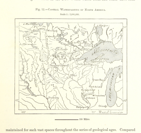
maps from the earth and its inhabitants, vol. xii
19th-century maps of the azores
maps from the earth and its inhabitants, vol. xiv
old maps of sydney
maps from the earth and its inhabitants, vol. xviii
1870s maps of peru
maps from the earth and its inhabitants, vol. iv
19th-century maps of cornwall
le désert et le monde sauvage
folivora illustrations
maps from the earth and its inhabitants, vol. xvi
1870s maps of mexico
maps from the earth and its inhabitants, vol. iv
1870s maps of london
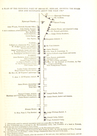
historical collections of the state of new jersey (1852)
maps of newark, new jersey
maps from the earth and its inhabitants, vol. vi
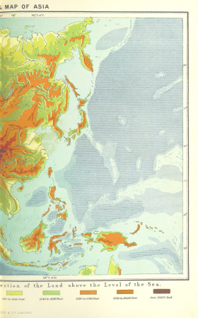
topographic maps of asia
maps from the earth and its inhabitants, vol. xiii
maps indicating exploration
illiteracy in france
education in france
maps from the earth and its inhabitants, vol. xviii
old maps of valparaíso
maps from the earth and its inhabitants, vol. viii
maps of the mekong
maps from the earth and its inhabitants, vol. iv
cirencester
maps from the earth and its inhabitants, vol. xiii
19th-century maps of madagascar
maps from the earth and its inhabitants, vol. iv
old maps of windsor
the lands of scripture (1879)
architecture bl
maps from the earth and its inhabitants, vol. iv
19th-century double hemisphere world maps
maps from the earth and its inhabitants, vol. iv
maps of tides
19th-century maps of namibia
maps of walvis bay
maps from the earth and its inhabitants, vol. iv
maps of the humber estuary
maps from the earth and its inhabitants, vol. iv
maps of rochester, kent
maps from the earth and its inhabitants, vol. xvi
old maps of central america
maps from the earth and its inhabitants, vol. xv
hydrological maps of the united states
maps from the earth and its inhabitants, vol. xvi
19th-century maps of mexico city
maps from the earth and its inhabitants, vol. xvi
19th-century maps of jamaica
maps from the earth and its inhabitants, vol. ii
st malo
maps from the earth and its inhabitants, vol. iv
charts of plymouth sound
westmorland, cumberland, durham, and northumberland (1858)
old maps of westmorland
2201 - 2300 of 6,983
Next page
/ 70